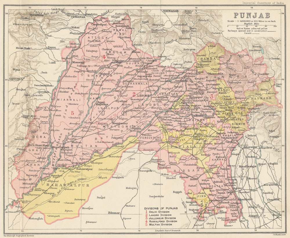
Everyone knows that Marwari and Seraiki are different languages. In Cholistan, the desert of the old Bahawalpur State, they have also become labels of religion. Marwari has become a Hindu identity and Seraiki a Muslim one, whatever a family speaks at home: the Hindus call themselves Marwari and speak Seraiki, and their Muslim kin call themselves Seraiki and still speak Marwari among their own. As I wrote in April, Hindus and Muslims there are hard to tell apart; the name of a language is now how they do it. Is either of them Punjabi?
A reader posted a map in our WhatsApp group in October: “Pre-Independence Punjab, Partitioned in 1947”, with Dera Ghazi Khan and Multan circled in red. His father’s family is from Bahawalpur State and his mother’s from Montgomery. Another reader said his family spoke Seraiki. I sent the same map to my Urdu teacher, a Seraiki speaker, and he picked out “Bahawalpur state” at once. The question underneath was the same one: which parts of that outline are actually Punjab?
My teacher has a stake in the answer. He is from Rajanpur, at the bottom of the province, and I wrote in September about the rice-flour dosa his family eats with saag. In 1947 Rajanpur was a tehsil of Dera Ghazi Khan district, one of the two circled on the map. His family moved to the city from Cholistan, and they are the Muslims of the opening. In a class on 6 November he told me that they call themselves Seraiki, that his grandfather spoke Marwari, and that they still speak a mixed Marwari with their own community. The Hindus, he said, call themselves Marwari and speak Seraiki. When I sent him my September post on Lahnda, he translated it into Urdu for his family group, and wrote back that the regional languages are part of the culture and should be kept.
That Lahnda post was about what happened inside the box: the canal colonies, Partition and the census. In 2019 I asked whether the British, entering from Bengal, re-Indianised the north-west, and Major Amin’s review of The Garrison State took up what the colonial Punjab was for: the army’s recruiting ground. This post is about the box itself. It was not drawn around a people. It was assembled in four moves by an administration that had other things in mind.
How the box was built
| Year | Move | Effect on the map |
|---|---|---|
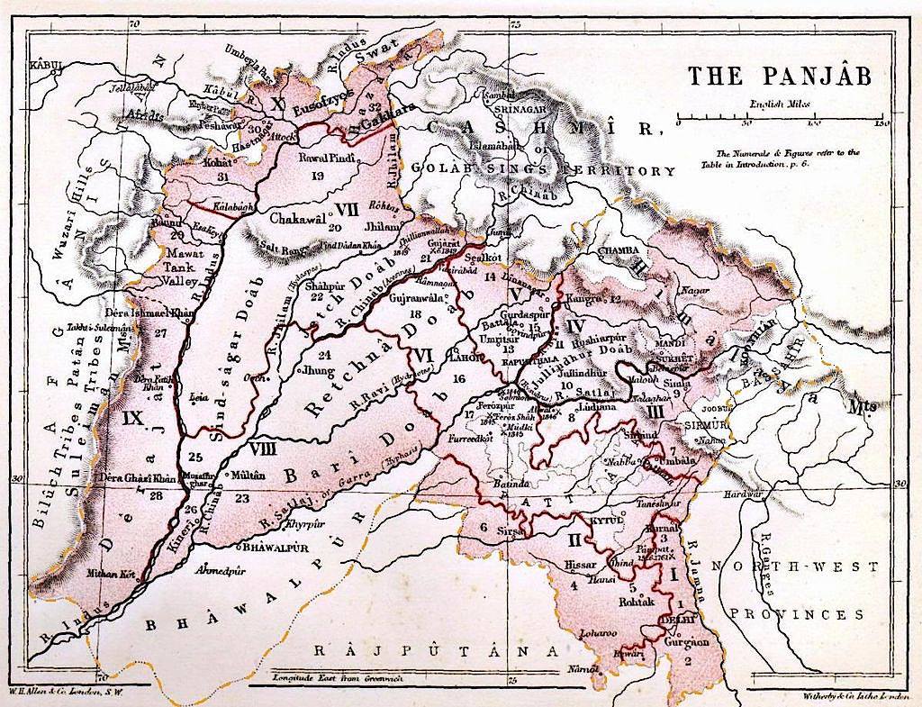
| 1849 | Annexation of the Sikh kingdom after the Second Anglo-Sikh War | The rest of the Lahore kingdom, from the Sutlej to the Indus and its lands beyond it, joins the cis-Sutlej tracts the Company already held as the Punjab |
| 1858 | The Delhi territory transferred from the North-Western Provinces after the rebellion | Delhi, Gurgaon, Rohtak, Hisar, Karnal and Sirsa join the Punjab |
| 1901 | North-West Frontier Province created | Peshawar, Hazara, Kohat, Bannu and Dera Ismail Khan leave; Dera Ghazi Khan, also across the Indus, stays |
| 1912 | Delhi made a separate province for the new capital | The Delhi enclave leaves |
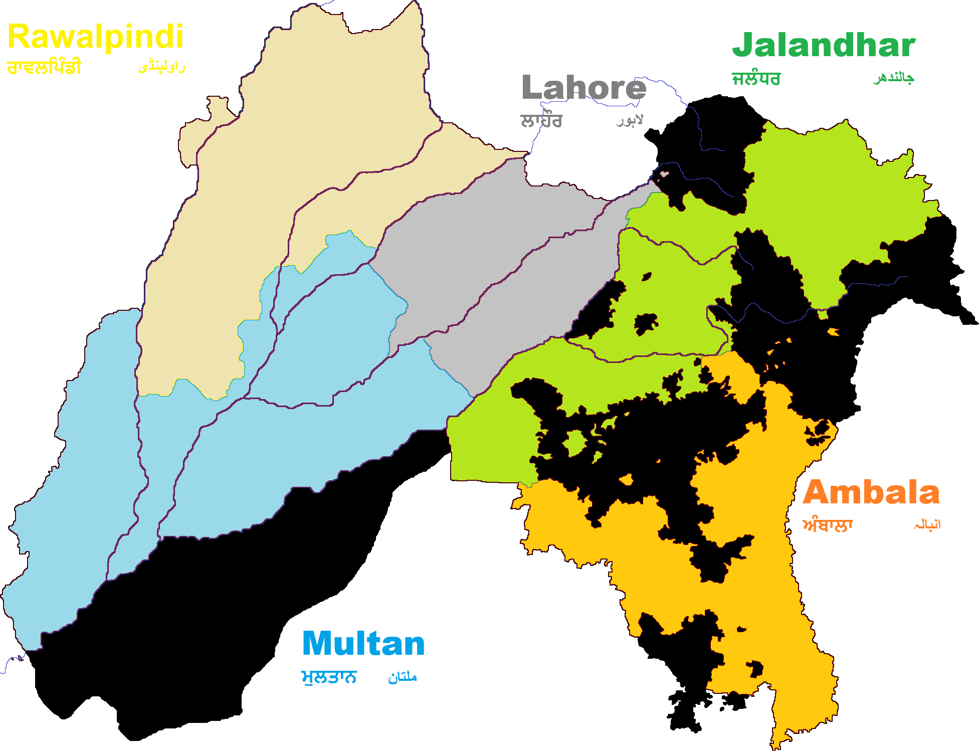
So the outline the reader posted is the Punjab after 1912. By 1947 it had twenty-nine British districts in five divisions, with the princely states of Bahawalpur, Patiala, Nabha, Jind, Kapurthala, Malerkotla, Faridkot, Chamba, Mandi, Suket and the Simla hill states inside the line but under their own rulers. The province was run by a Lieutenant-Governor from 1859 to 1921 and a Governor after that.
That answers the question in the thread about the name on the map. Sir Robert Montgomery was Lieutenant-Governor of the Punjab from 1859 to 1865. In 1864 the headquarters of Gogaira district moved to a station on the railway line, which was named Montgomery after him in 1865, and the district took the name; the town and district became Sahiwal in 1966. Lyallpur, named for Sir James Lyall, Lieutenant-Governor from 1887 to 1892, became Faisalabad in 1977. Two of the names on the map are British officials, and both have since been removed.
Three Punjabs
The word carries three meanings that the map runs together.
The first is the land of the five rivers: Jhelum, Chenab, Ravi, Beas and Sutlej, which is to say the doabs between them, the Sindh Sagar Doab west of the Jhelum, and the Bist Doab between the Beas and the Sutlej. On that reading Punjab ends at the Indus to the west, at the Sutlej to the south-east, and at the Siwaliks to the north-east. Malwa, south of the Sutlej, is outside the rivers but Punjabi in speech, which is where the first two meanings part.
The second is the Punjabi language, in its central dialects, Majhi, Doabi, Malwai and Powadhi, and its western ones, Shahpuri, Dhani and Jhangvi. The edges are disputed. Potohari, spoken on the plateau around Rawalpindi, has no column of its own in the Pakistani census and is listed as a separate language, Pahari-Potwari, by Ethnologue. Seraiki, spoken from Jhang southwards, has been a separate census language in Pakistan since 1981. My teacher put the gap in practical terms: by his own estimate a Seraiki speaker and a Pothohari speaker understand about thirty per cent of each other’s speech, and the food, the dress and the accent differ as well.
The third is political: whatever a government calls Punjab today. On the Indian side that was cut back to the Punjabi-speaking districts in 1966. On the Pakistani side the 1947 box, minus the Indian share and Islamabad and plus Bahawalpur, has never been divided on language.
Sorting the twenty-nine districts
This is my grouping of the districts against the first two meanings. The margins are mixed: Hoshiarpur, Gurdaspur and Ambala were split in 1966, and Patiala and Jind held land on both sides of the language line.
| Group | Districts and states on the 1947 map | Test |
|---|---|---|
| Core Punjab | Lahore, Amritsar, Gurdaspur, Sialkot, Gujranwala, Sheikhupura, Gujrat, Shahpur, Jhelum, Lyallpur, Montgomery, Jalandhar, Hoshiarpur, Ludhiana, Firozpur; Kapurthala, Patiala, Nabha, Jind, Malerkotla, Faridkot | Inside the five rivers, or in Malwa south of the Sutlej, and Punjabi-speaking (Lyallpur and Montgomery by settlement from the central districts; the older speech of the bar was Jhangvi) |
| Transitional | Rawalpindi, Attock, Jhang, Mianwali | Potohari and Hindko in the north; Jhangvi shading into Seraiki; Mianwali mostly Seraiki and Thalochi, with Pashto in Isa Khel |
| Seraiki south-west | Multan, Muzaffargarh, Dera Ghazi Khan; Bahawalpur State | Multan was its own province under the Mughals, separate from Lahore. Dera Ghazi Khan is across the Indus and Baloch in its tribes. Bahawalpur’s rulers, the Daudpotra Abbasis, came from Shikarpur in Sindh in the eighteenth century |
| Haryana | Hisar, Rohtak, Gurgaon, Karnal, and the plains of Ambala | Haryanvi and Bagri speech, Jat and Ahir country of the Delhi region; except for Ambala, in the Punjab only because of 1858 |
| Hills | Kangra, Simla; Chamba, Mandi, Suket and the Simla hill states | Western Pahari languages, Kangri and its neighbours; the Siwaliks and beyond |
By my count fifteen of the twenty-nine districts are Punjab in both the river and the language sense, and four more are transitional. Three in the south-west are Seraiki, with Bahawalpur State beside them; five in the south-east are Haryanvi; and two in the north-east are Pahari. The two circled districts, and the state below them, are exactly the parts of the map with the weakest claim to the name.
What 1947 and 1966 did with the box
Partition cut the box along a line that Radcliffe drew in five weeks, through the core: Lahore west, Amritsar east, Gurdaspur split at the tehsil. It did not touch the question of where Punjab ends.
India then answered that question. The princely states east of the line had become PEPSU in 1948, and PEPSU was merged into Punjab in 1956. The Punjab Reorganisation Act of 1966 took Hisar, Rohtak, Gurgaon, Karnal and Mahendragarh out as Haryana, with parts of Ambala district and the Jind and Narwana tehsils; gave Simla, Kangra, Kullu, Lahaul and Spiti, the Nalagarh tehsil and parts of Hoshiarpur and Gurdaspur to Himachal Pradesh; made Chandigarh a union territory; and left an Indian Punjab close to the Punjabi-speaking districts. The States Reorganisation Commission had refused a linguistic Punjab in 1955; the Punjabi Suba movement got it eleven years later, and the state that resulted is a Punjab whose boundary was argued on the ground of speech. Pakistan’s never has been. In the notes to a 2019 podcast with Professor Majeed I called this the great victory of the Sikhs: Punjabi is a vigorous language of state in India in a way that it is not in Pakistan.
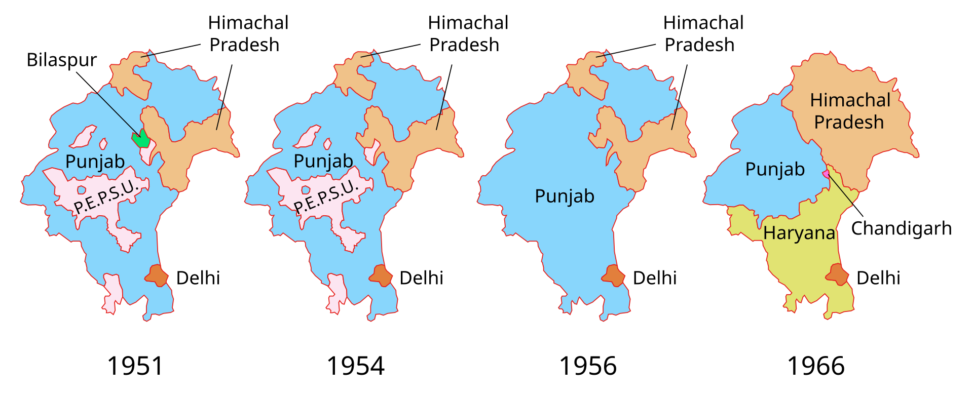
Pakistan kept the box. Bahawalpur State, which acceded to Pakistan in October 1947, lost its separate existence in One Unit on 14 October 1955 and came out of One Unit in July 1970 as districts of Punjab, not as itself; I have asked whether Pakistan should restore its princes. The Seraiki districts, the Potohar plateau and the central doabs sit in one province of 127.7 million people at the 2023 census, and the argument about new provinces that opened my Lahnda post is an argument about whether to do what India did in 1966. In 2018 I wrote, in The Siraiki question, that Pakistani Punjab had not had its Haryana moment yet. It still has not. Urdu has done some of the binding instead; an earlier post argued that it works as a link language inside a province with large linguistic minorities. The map the reader posted is the reason the argument exists.
What the map shows
Punjab, in river and in speech, runs from the Indus to the hills, and south of the Sutlej across Malwa as far as Punjabi is spoken. The 1947 outline runs past it because the British added the Delhi districts in 1858 and kept Dera Ghazi Khan in 1901. India corrected the eastern and northern overshoots in 1966. The western and southern overshoots are still on the map, and they are what the people of Multan, Dera Ghazi Khan and Bahawalpur mean when they say they are not Punjabi.