The Hindification of East India

The Saffron Block

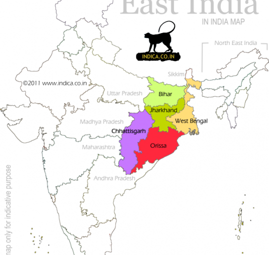
The map of East India has changed colour. Bihar fell to the NDA in November 2025 with 202 of 243 seats, and Samrat Choudhary now sits as the first BJP Chief Minister Bihar has ever had. Odisha went saffron in 2024 under Mohan Charan Majhi. On 4 May 2026 Mamata Banerjee lost Bengal after fifteen years; the BJP took 206 seats and will form its first government in Kolkata. Himanta Biswa Sarma returned in Assam with 82 seats, a two-thirds majority and a third consecutive term. The old Bengal Presidency, once the largest province of British India, is now a single saffron block.

This is the completion, by ballot, of a partition the British attempted by map.

1905

In 1905 Curzon split Bengal. The eastern half was to be Muslim and centred on Dhaka; the western half was to be joined to Bihar and Orissa, which made the Bengalis a linguistic minority in their own province. The Bengali Hindu elite, the bhadralok who ran Bengal’s commerce and letters, fought it bitterly. They did not want to be drowned by Bihari and Oriya numbers. In 1911 the British relented and reunited Bengal.

The Biharis, for their part, had spent two decades campaigning to escape Bengali domination. The 1912 reorganisation that gave them their own province, jointly with Orissa, was their reward.

Linguistic identity then was the prime axis. Hindu and Muslim mattered, but not as much as Bengali, Bihari, Oriya.

The Historical Axis Flipped

A century on, that axis has flipped. The Bengali, the Bihari, the Oriya and the Assamese are voting as Hindus, and they are voting for the same party. The two-nation theory, which Bengal once threw off, is doing its work the long way round.

Hindi,, Hindu, Hindustan
Continue reading The Hindification of East India

Two Colonisations, One Border: What the Data Actually Says About Bengal’s Post-1971 Demographic Story

Check BB’s personal anecdote on the Northeast.

As mentioned, the Special Intensive Revision of electoral rolls in West Bengal has removed 9.1 million names, 2.7 million of them under contested adjudication. The argument has compressed itself into two bad positions. Either every deletion is disenfranchisement, or every deletion is a Bangladeshi caught. Neither is true, and the census of the last hundred years tells a more specific story than either side wants.

The received wisdom on Northeast India collapses into one sentence: Bangladeshi Muslims are flooding across the border. The received wisdom is partly wrong and mostly incomplete. A narrower reading of the census, focused on the actual border districts, tells a stranger story. There are two demographic colonisations in eastern India, not one. They run in opposite religious directions, and Indian statecraft has treated them as opposites: one ratified, one criminalised.

Tripura: the Hindu Bengali takeover

Tripura*: 1951: 71% Hindu, 7% Muslim (with ~21% still counted under tribal religions separately).

Today: 83% Hindu, 9% Muslim.

In 1941, tribals were 50% of Tripura. By 2011, 32%. Partition and the 1971 war did the rest.

The population that replaced the Kokborok, Reang, and Jamatia is Bengali Hindu, not Muslim. Tripura’s Muslim share today is 9%, below the all-India average. The Northeast state most transformed by Partition and 1971 is the one that became a Hindu Bengali colony.

South Tripura district is the cleanest data point. The ST share there is 17%. The Bengali Hindu majority there is overwhelmingly composed of descendants of refugees who crossed between 1947 and 1971.

*Note on Tripura: the Hindu figure jumped partly because tribals were reclassified as Hindu between 1951 and 1971 in the census. Real Hindu Bengali influx adds on top of that statistical shift.

Assam border districts: the Muslim Bengali case

Assam: 1951: 72% Hindu, 25% Muslim.

Today: 61% Hindu, 34% Muslim. Continue reading Two Colonisations, One Border: What the Data Actually Says About Bengal’s Post-1971 Demographic Story

Brown Pundits